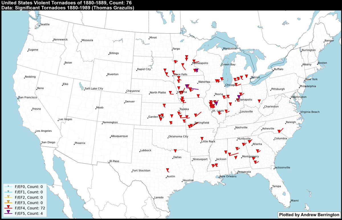
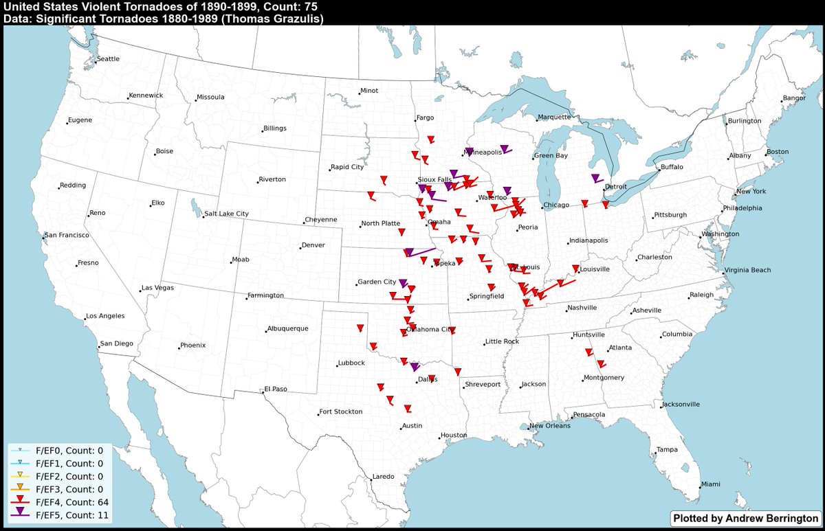
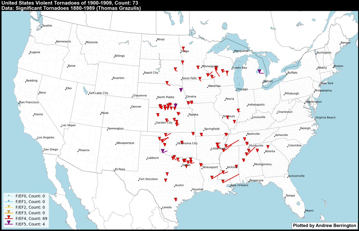
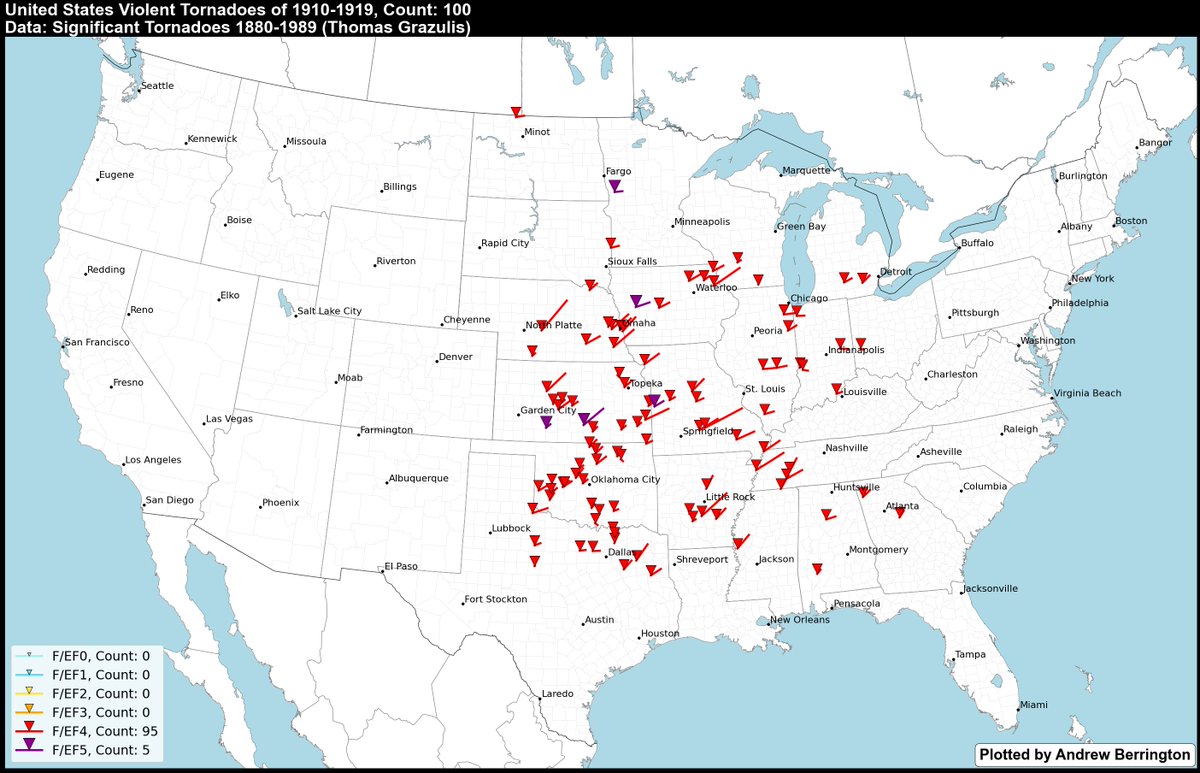
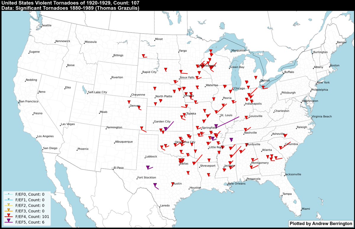
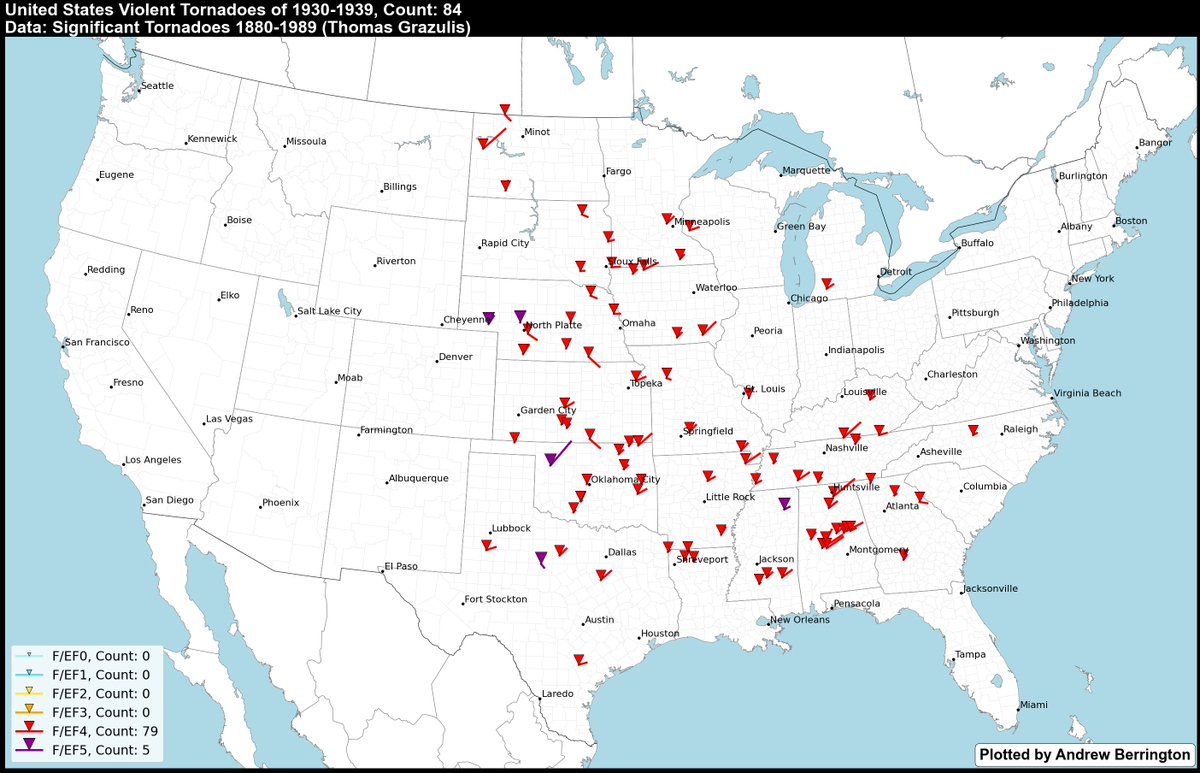
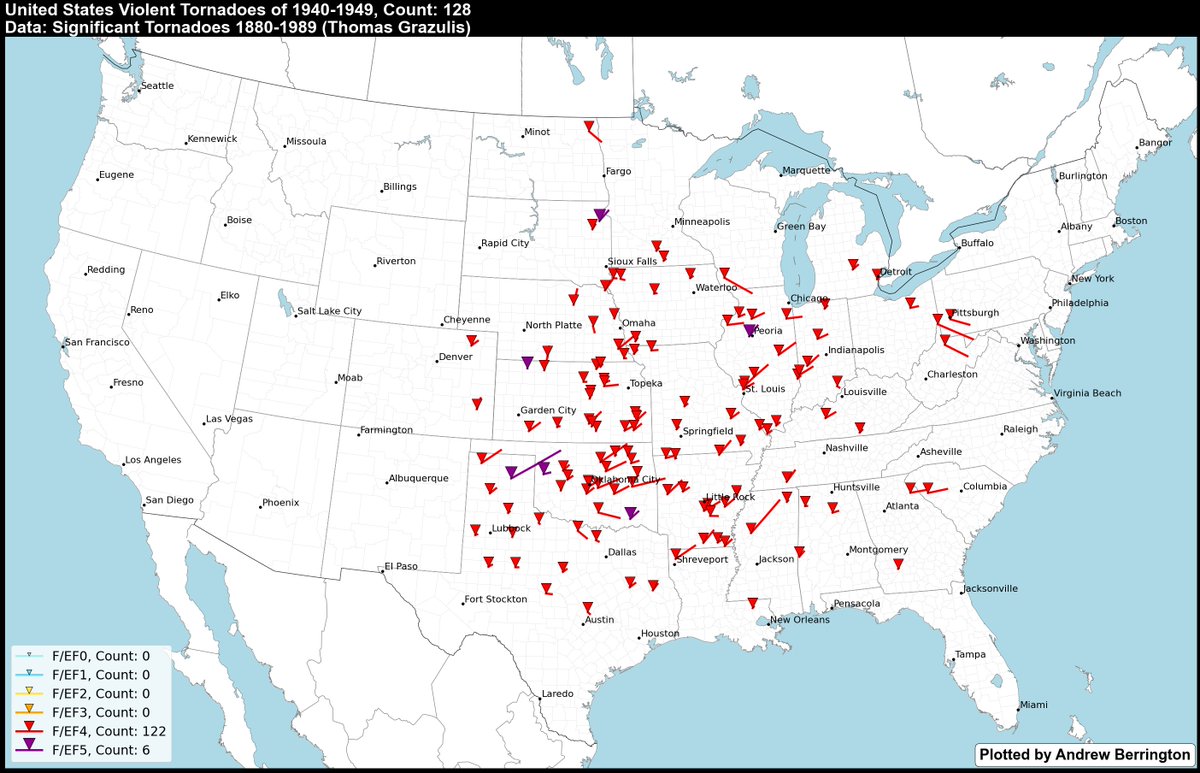
Thread: As an avid tornado history guy, I've always marveled at @sigtor2019's work in documenting tornadoes. I've wondered how they would look plotted on a map. So that's what I did, for all 643 F4+ tornadoes in the 1880-1949 period. Plotted by decade starting w/ 1880-1889. 1/20
Notable events in this period include the 4/18/1880 outbreak (Marshfield MO F4), 6/17/1882 (Grinnell IA F5), the 5/18/1883 outbreak (Upper Midwest), 2/19-20/1884 (the Enigma outbreak), and the 4/14/1886 outbreak (St. Cloud/Sauk Rapids MN F4). 2/20
Notable events in this period include the 3/27/1890 outbreak (Louisville KY F4), the 9/21/1894 outbreak (Upper Midwest), the May 1896 outbreak sequence (Sherman TX and Ortonville MI F5s + St. Louis/East St. Louis F4), and the 5/18/1898 outbreak (Midwest). 4/20
Notable events in this period include 5/18/1902 (Goliad TX F4), 5/10/1905 (Snyder OK F5), 4/23-24/1908 (Central Plains and Dixie outbreak), 6/5/1908 (N KS/S NE outbreak), and 4/29-30/1909 (Mid South outbreak). 6/20
Notable events in this period include the late April 1912 outbreak sequence (S Plains + Midwest), the 3/23/1913 outbreak (Omaha NE F4 and Midwest), the late May/early June 1917 outbreak sequence (Mattoon IL F4), and the 4/8-9/1919 outbreak (E TX violent tornadoes at night). 8/20
Notable events in this period include the 3/28/1920 outbreak (Palm Sunday I), the 4/20/1920 outbreak (Dixie), 3/18/1925 (Tri-State tornado), the 4/12/1927 Rocksprings TX F5, and the 5/7-9/1927 outbreak (Poplar Bluff MO F4). 10/20
Notable events in this period include the early May 1930 outbreak sequence (Frost TX F4), the 3/21-22/1932 outbreak (Dixie especially AL), the 5/10/1933 outbreak (Tompkinsville KY and Beatty Swamps TN F4s), and the 4/5-6/1936 outbreak (Tupelo MS F5 + Gainesville GA F4). 12/20
Notable events in this period include the 3/16/1942 outbreak (Midwest + Lower MS Valley), 6/23/1944 (PA/MD/WV violent tornadoes), the 4/12/1945 outbreak (Antlers OK F5), 4/9/1947 (Glazier/Higgins TX and Woodward OK F5), and the May 1949 outbreak sequence (S Plains/Midwest). 14/20
Have been wanting to visualize these en masse for quite awhile and used Significant Tornadoes 1880-1989 as the reference + @googleearth + @googlemaps + @matplotlib to make it happen in terms of finding lat/lon coordinates. 15/20
There are some caveats. Tornado ratings in this period are not considered "official", but @sigtor2019 did an excellent job in scrutinizing the damage from thousands of tornadoes in his research. Many of the long paths are likely cyclic supercells producing tornado families. 16/20
In addition, tornado paths are obviously more complex in most cases than a straight line, therefore there may be some discrepancies here, but I had a hierarchy of importance when mapping these that went something like... 17/20
1. Get the start/end points if listed in the tornado's description.
2. Towns/cities struck.
3. Towns/cities near the path.
4. Counties crossed.
5. Path length.
18/20
2. Towns/cities struck.
3. Towns/cities near the path.
4. Counties crossed.
5. Path length.
18/20
Again, I want to acknowledge @sigtor2019's incredible work (it's honestly mind-boggling) in putting together such detailed climatologies for tornadoes going back to the early days of the United States. I look forward to purchasing the updated book when it is released. 19/20
I am simply taking the data presented by his material and visualizing it using the help of GIS and Python. "Standing on the shoulders of giants", if you will. 20/20

 Read on Twitter