“Miserable conditions in the flooded displacement camps in Idlib and other areas” reported by @MarkCutts
Freezing weather - Harsh winter cold & rain flooding - is impacting the 500K+ civilians displaced by the war in #Idleb & #Aleppo, #Syria
SHORT THREAD (1/5)
Freezing weather - Harsh winter cold & rain flooding - is impacting the 500K+ civilians displaced by the war in #Idleb & #Aleppo, #Syria
SHORT THREAD (1/5)
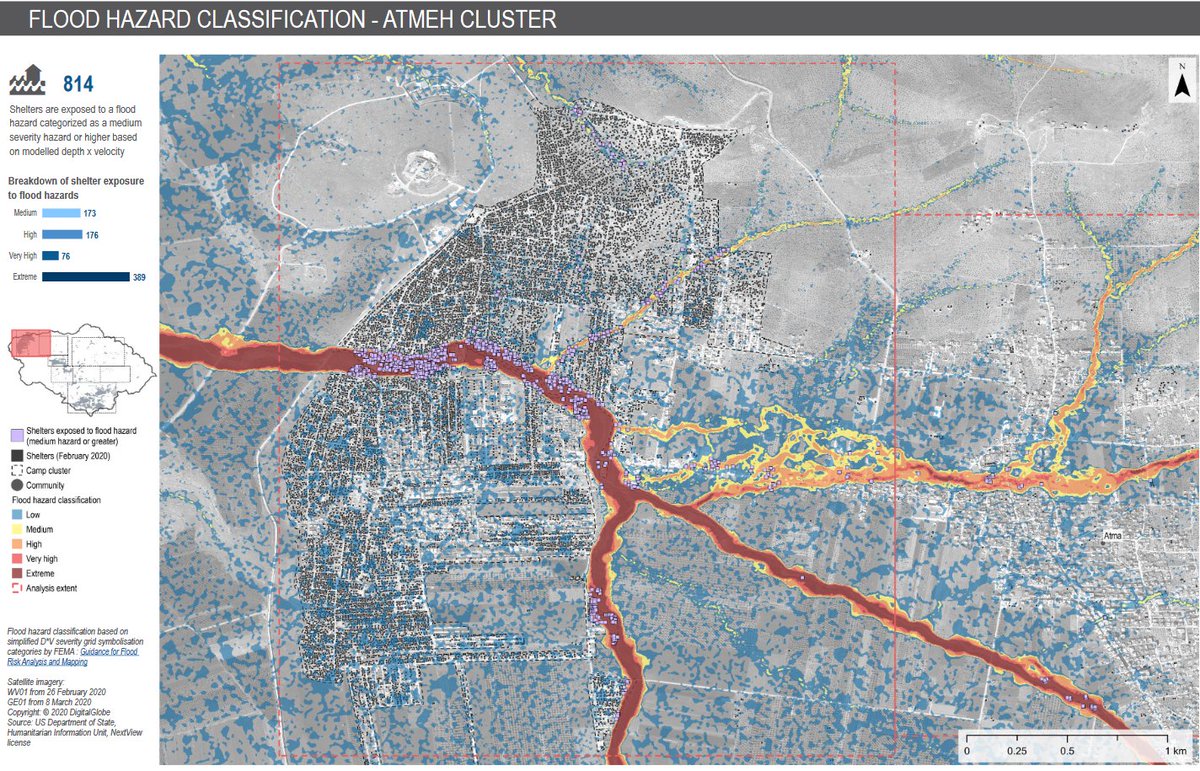
Using #remotesensing in #IDP camps in NW #Syria @REACH_info mapped water catchment areas to identify #flood hazards
The map shows that there are 2500+ IDP shelters exposed to significant flash flooding hazards in the densely populated sub-district of northern Dana
(2/5)
The map shows that there are 2500+ IDP shelters exposed to significant flash flooding hazards in the densely populated sub-district of northern Dana
(2/5)
How does detailed hydraulic modeling work?
In partnership w @UNOSAT the process follows rigorous steps:
-nationwide flood susceptibility mapping
- identification of priority areas
- shelter / settlement analysis (eg. building footprints)
- detailed hydraulic modeling
(3/5)
In partnership w @UNOSAT the process follows rigorous steps:
-nationwide flood susceptibility mapping
- identification of priority areas
- shelter / settlement analysis (eg. building footprints)
- detailed hydraulic modeling
(3/5)
On top of this, REACH teams in Syria continuously updates multi-sectoral data on #needs & #vulnerabilities, and wider #humanitarian conditions, of communities living in the crisis-affected areas in Northern part of #Syria
This is the #Emergency Needs Tracking System
(4/5)
This is the #Emergency Needs Tracking System
(4/5)
More information on how the combination of such #research and the #data collected can help communities living in Northern Syria build their resilience to these ongoing shocks, and how #humanitarians can improve their response  https://www.reach-initiative.org/what-we-do/news/building-tools-improve-response-resilience-syria-floods/
 https://www.reach-initiative.org/what-we-do/news/building-tools-improve-response-resilience-syria-floods/

 Read on Twitter


