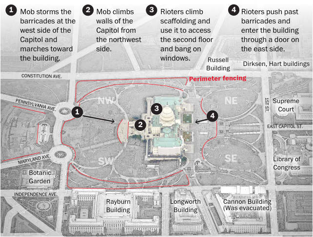
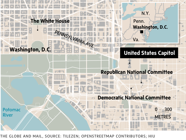
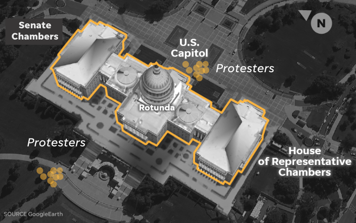
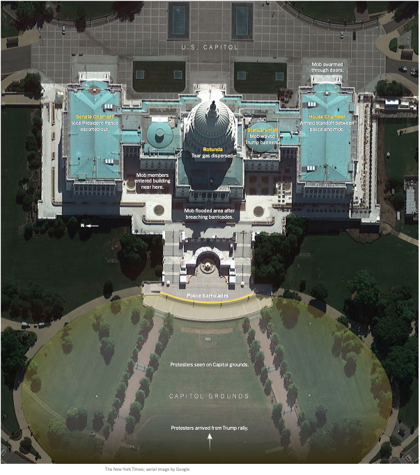
if you’re interested in breaking news graphics, here’s a roundup thread of how different outlets covered yesterday’s Capitol insurrection (collected this morning)
some takeaways. Three graphics dominated: a) aerial shot of the Capitol Building and surroundings b) Capitol close up 3) Capitol floor plans
so first up, the aerial shots. We see a mix of satellite and vector maps (but mostly vector)
New York Times
https://www.nytimes.com/interactive/2021/01/06/us/trump-mob-capitol-building.html?action=click&module=Top+Stories&pgtype=Homepage
https://www.nytimes.com/interactive/2021/01/06/us/trump-mob-capitol-building.html?action=click&module=Top+Stories&pgtype=Homepage
NBC (my team! we used datawrapper)
https://www.nbcnewyork.com/news/politics/electoral-college-updates-congress-set-to-confirm-bidens-win-amid-gop-challenges/2814845/
https://www.nbcnewyork.com/news/politics/electoral-college-updates-congress-set-to-confirm-bidens-win-amid-gop-challenges/2814845/
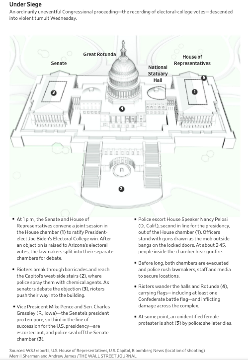
Wall Street Journal (twitter preview isn't doing good things to this one so click the link)
https://www.wsj.com/articles/capitol-police-werent-prepared-for-rioters-authorities-say-11609978798
https://www.wsj.com/articles/capitol-police-werent-prepared-for-rioters-authorities-say-11609978798
The Globe and Mail (hey, I'm Canadian)
https://www.theglobeandmail.com/world/us-politics/article-trump-supporters-engage-in-historic-attacks-on-us-democracy-on-a-day/
https://www.theglobeandmail.com/world/us-politics/article-trump-supporters-engage-in-historic-attacks-on-us-democracy-on-a-day/
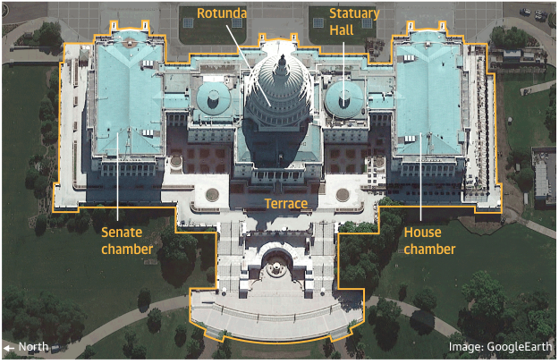
next, the Capitol close ups. Mostly annotated Google Earth stills
The New York Times
https://www.nytimes.com/interactive/2021/01/06/us/trump-mob-capitol-building.html?action=click&module=Top+Stories&pgtype=Homepage
https://www.nytimes.com/interactive/2021/01/06/us/trump-mob-capitol-building.html?action=click&module=Top+Stories&pgtype=Homepage
The Wall Street Journal
https://www.wsj.com/articles/trump-allies-in-congress-challenge-bidens-election-win-11609929001?reflink=desktopwebshare_twitter&mod=e2twg
https://www.wsj.com/articles/trump-allies-in-congress-challenge-bidens-election-win-11609929001?reflink=desktopwebshare_twitter&mod=e2twg
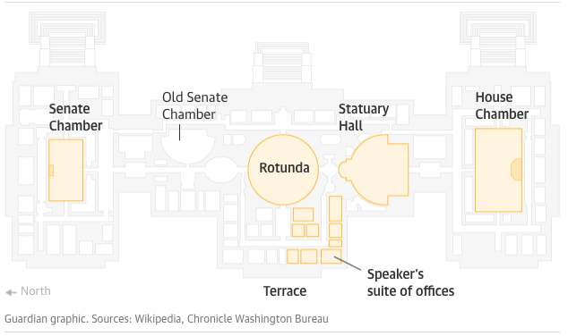
The Guardian
https://www.theguardian.com/us-news/2021/jan/07/how-a-mob-of-trump-supporters-stormed-the-capitol-visual-guide
https://www.theguardian.com/us-news/2021/jan/07/how-a-mob-of-trump-supporters-stormed-the-capitol-visual-guide
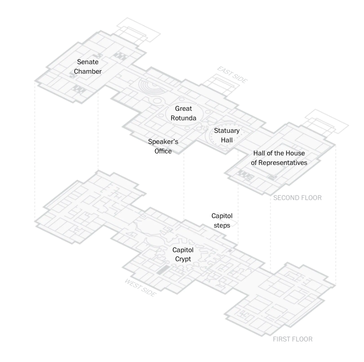
lastly, the floor plans. Fascinating to see the same floor plans all styled so differently
The New York Times
https://www.nytimes.com/interactive/2021/01/06/us/trump-mob-capitol-building.html?action=click&module=Top+Stories&pgtype=Homepage
https://www.nytimes.com/interactive/2021/01/06/us/trump-mob-capitol-building.html?action=click&module=Top+Stories&pgtype=Homepage
The Guardian
https://www.theguardian.com/us-news/2021/jan/07/how-a-mob-of-trump-supporters-stormed-the-capitol-visual-guide
https://www.theguardian.com/us-news/2021/jan/07/how-a-mob-of-trump-supporters-stormed-the-capitol-visual-guide
The Washington Post
https://www.washingtonpost.com/politics/interactive/2021/video-timeline-capitol-breach/?utm_medium=social&utm_source=twitter&utm_campaign=wp_graphics
https://www.washingtonpost.com/politics/interactive/2021/video-timeline-capitol-breach/?utm_medium=social&utm_source=twitter&utm_campaign=wp_graphics
h/t to all of the incredible visual journalists who jumped into action yesterday. It’s really challenging to do this work in real time, but it helps a lot of people understand what’s going on better and faster
also, I just did this for fun, so I’m probably missing a bunch (please send them to me!). Mostly larger outlets here, but hope you get something out of it!

 Read on Twitter