Why so much fog and low clouds lately?
(a fun meteorology lesson/thread! )
)
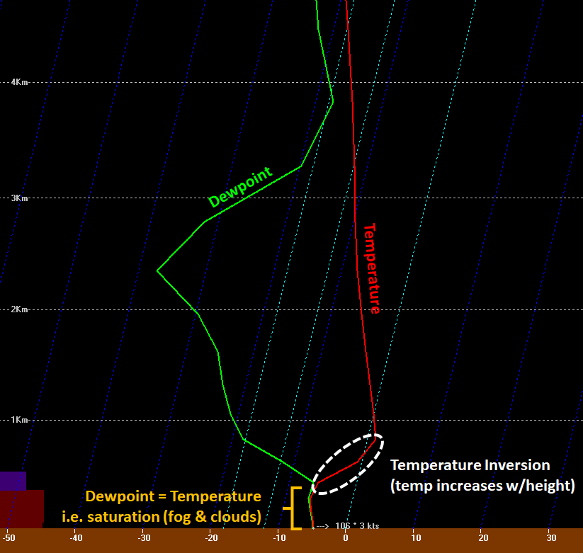
In simple terms, we've been stuck in a mucky pattern where moisture has been "trapped" in the lower atmosphere beneath a persistent, pronounced temperature inversion about 1/2 km above the ground. (1/6)
(a fun meteorology lesson/thread!
 )
)In simple terms, we've been stuck in a mucky pattern where moisture has been "trapped" in the lower atmosphere beneath a persistent, pronounced temperature inversion about 1/2 km above the ground. (1/6)
A temperature inversion is where temperatures increase with height. The sharper the increase, the stronger the inversion and the greater its "moisture trapping" effect. (2/6)
The graphic above is a plot we use as forecasters which shows a weather model's depiction of temperature and dewpoint changes with height over a given location at a given time, in this case La Crosse at midnight tonight. (3/6)
It's basically a vertical snapshot of the atmosphere at a given hour. We've detailed the features of interest, but you can see the stout temp inversion from about 1/2 to 1 km aloft. (4/6)
Beneath the inversion, the dewpoint and temperature lines practically overlap, implying they are nearly equal, producing ~100% relative humidity. This yields a layer of low clouds and fog. (5/6)
This mucky pattern tends to persist until some larger weather system comes through to weaken/erode the temperature inversion, or until the lower atmosphere can dry out sufficiently. Well, we're not seeing any big pattern change coming over the next few days... (6/6)

 Read on Twitter


