A tip for Google Earth & GEOINT enthusiasts.
Ever wonder from which direction a satellite took it's photos without actually pouring thru data to find out? There's a quick way that can help bring out detail & gain perspective for your spots.
Take this image for example.
1/
Ever wonder from which direction a satellite took it's photos without actually pouring thru data to find out? There's a quick way that can help bring out detail & gain perspective for your spots.
Take this image for example.
1/
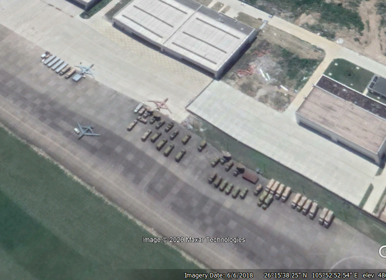
This 6/6/2018 Google Earth image of the 162 Factory for Guizhou  UAV production shows 3x Guizhou EA-03 "Soar Dragons" along with their control trucks and satellite dishes. Right now, the image is oriented North. Can you see which direction the satellite is oriented?
2/
 UAV production shows 3x Guizhou EA-03 "Soar Dragons" along with their control trucks and satellite dishes. Right now, the image is oriented North. Can you see which direction the satellite is oriented?
2/
First, find a tall building within your satellite photo and look at the corners. Any production building is going to have nice perpendicular walls that need to be perfectly vertical. The most exposed corner is going to be your focus. You will use this corner for orientation.
3/
3/
Rotate your map around until that corner appears to point straight up to the top of your screen. And that's it! Make sure you are not using the lines of shadows because the sun has it's own angles and can create confusion.
4/
4/
From there, adjust zoom and see it like you you would see it from a bird's eye view rather than askew or upside down. Enjoy!
5/end
5/end

 Read on Twitter


