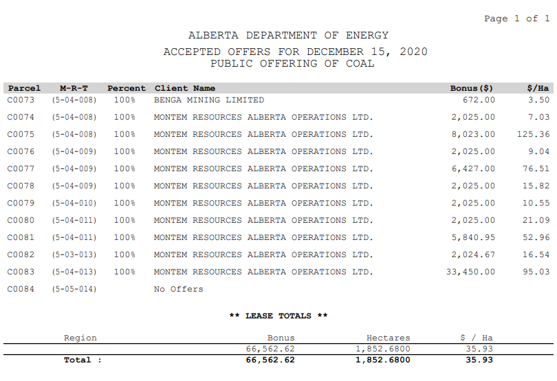
A lot of people have been tweeting about the new coal leases that were just issued in Southern Alberta: https://open.alberta.ca/dataset/42128e13-9e5c-46e5-b86d-9f7895d60dfe/resource/55bbc563-14c2-450a-8930-e679910464c5/download/energy-accepted-offers-public-offering-of-crown-coal-rights-offered-2020-12-15.pdf
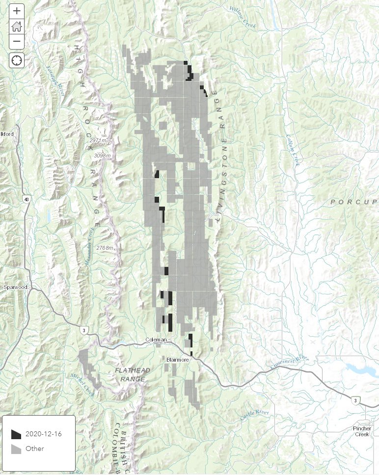
For those wondering *where* these are, exactly, here's a map.
New leases in black. Existing leases in grey.
For those wondering *where* these are, exactly, here's a map.
New leases in black. Existing leases in grey.
Note that a coal lease doesn't mean a company can start mining right away. There are currently no mining licences issued in the area.
One project (Grassy Mountain) has gone quite far down the regulatory process and is getting close to a final decision: https://www.cbc.ca/news/canada/calgary/crowsnest-pass-mining-hearing-1.5776974
One project (Grassy Mountain) has gone quite far down the regulatory process and is getting close to a final decision: https://www.cbc.ca/news/canada/calgary/crowsnest-pass-mining-hearing-1.5776974
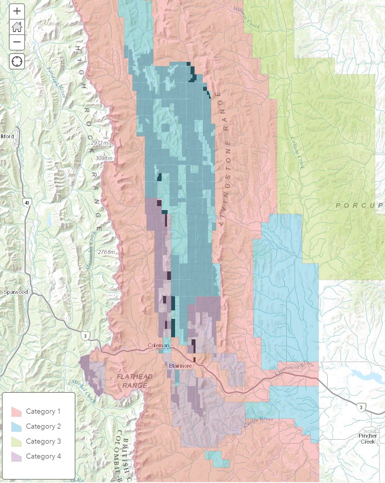
Also note that many leases are on former Category 2 land as defined by Alberta's old Coal Development Policy: https://open.alberta.ca/dataset/cc40f8f5-a3f7-42ce-ad53-7521ef360b99/resource/802d6feb-04ae-4bcc-aac3-3b3be31a0476/download/1114651976coal-development-policy-for-alberta1976-06.pdf
The policy was created in 1976 & it banned open-pit mining on Category 2 lands, indicated here in blue.
The coal policy was rescinded in June.
The policy was created in 1976 & it banned open-pit mining on Category 2 lands, indicated here in blue.
The coal policy was rescinded in June.
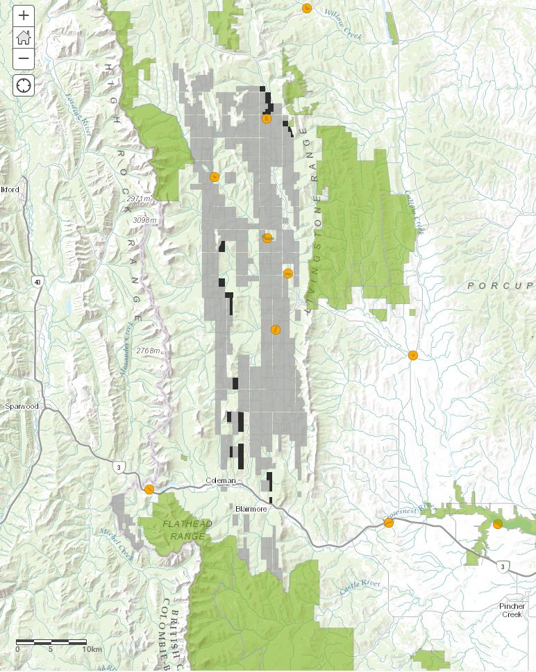
A lot of people have also been asking where these leases are situated relative to Alberta's parks.
This map shows protected areas in green. The orange dots are provincial recreation areas on the province's list of sites proposed for partnership / removal from the parks system.
This map shows protected areas in green. The orange dots are provincial recreation areas on the province's list of sites proposed for partnership / removal from the parks system.
If you're interested in more information, and have time to read 8,000 (!) words on the topic, here's a feature story @DrewPAnderson, @jordanomstead & I did on coal in Alberta earlier this year: https://newsinteractives.cbc.ca/longform/bringing-coal-back
If you're looking for something a little more, um, succinct... here's a 4-minute video we also made, that hits the key points:

 Read on Twitter


