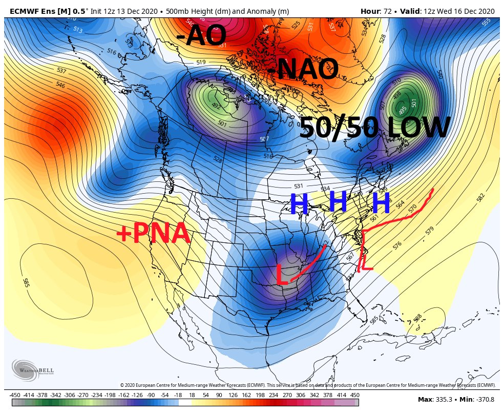
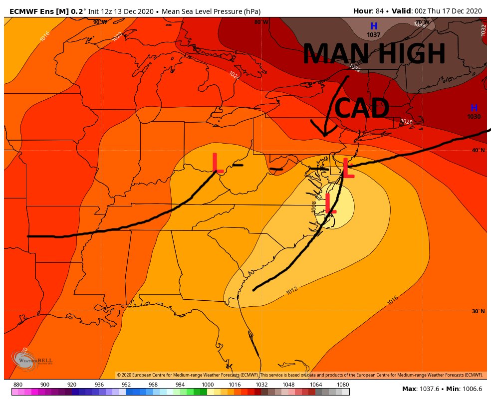
So lets go over the setup here. If anyone has ever read the book northeast snowstorms by Kocin/Uccellini this is straight from their book of a text book snow storms setup for the big cities and or just outside of the big cities. We can see from the 500mb map below we have strong
arctic blocking with a -AO and -NAO. There are two type of -NAO's east base and west base. East base is high pressure that builds into eastern Greenland, not as favorable for snow storms here. West base -nao is when high pressure builds through Greenland and into the Davis
Straits. We can also see we have a big area of low pressure what we call a 50/50 low as it's at 50 longitude and 50 latitude. So it's a train reaction here. -NAO blocks in the 50/50 low. 50/50 low being blocked in then blocks in a strong area of high pressure in northern new eng
The area of High pressure funnels cold air south into the coastal plain, which is needed for wintry precip. So we have the cold air now we need a storm system to attack that. We have a potent area of energy that enters the west coast tonight and swings through the southern tier
into the Miss river Valley, that is our storm. Looking at the trough and ridge locations we have a +pna ridge axis that is on the west coast. This is not ideal normally for winter storms here, usually with a ridge axis there it argue for a storm to cut to our west. Because we
have such a strong blocking mechanism our Primary low does indeed form and cut to our west as the longwave pattern dictates, but it can only go so far before hitting a brick wall (high pressure) at that point it has to redevelop eastward as secondary area of low pressure
This area of low pressure forms along the outer banks and heads almost due north. Swinging back to the surface pressure map we have a big "MAN HIGH" 1037 mb high that funnels cold air down the east side of the APP MTNS. we call this CAD or cold air damming. This supplies the
cold air for snow/ice. This setup where we have a primary low that cuts to our west then reforms along the coast is what we call a miller B type storm setup. These storms generally favor nyc and Boston because they form usually at our latitude. Since we have such strong blocking
here it is forming much further south. In these types of storms the key here is when the transfer occurs from the primary low to the secondary low. Basically the primary low hands off its energy to the secondary low, at that point the secondary low can start to really deepen.
A rule of thumb is you do not want to be south of the primary lows latitude if you want to remain all snow. So it's key here as to where the handoff of energy occurs. It looks to occur somewhere between Philly and DC. Why this is crucial is because before the handoff of energy
occurs the winds in the mid levels of the atmosphere are ripping from the east/southeast which is a warm wind. This causes temperatures to warm in the mid levels of the atmosphere to warm above freezing and flips the snow to ice/rain. Once the hand off occurs and the coastal
takes over the winds switch from east/southeast to the north/northeast which funnels colder air in and keeps the precip as snow or changes the precip over to snow.
So once the the handoff of energy occurs somewhere off delmarva or near Cape may the storm slows a little then starts to feel the effects of the blocking to the north and can't continue to move north so it slides east northeast. For accumulations in the city we need to figure
out when this transfer of energy occurs. If it occurs at philly's latitude then there will be a changeover to rain most likely. If this transfer occurs south of the city they should predominately stay snow. If if if if the city stays all snow, we are looking at 6"+ easily.
The best shot of highest snow totals right now are from elverson-pottstown-quakertown area on northwest. Where mixing (as of right now) should be little or not occur at all.

 Read on Twitter


