This paper shows the potential of GIS techniques for research on school choice policies and for educational planning. A brief synthesis of the main findings: (1/6) https://twitter.com/xavierbonal/status/1335488192787722240
 https://twitter.com/xavierbonal/status/1335488192787722240
We simulated two different scenarios:
1) 𝗖𝗮𝘁𝗰𝗵𝗺𝗲𝗻𝘁 𝗮𝗿𝗲𝗮.All students were assigned to the school situated in their catchment area of residence.
2) 𝗡𝗲𝗮𝗿𝗲𝘀𝘁 𝘀𝗰𝗵𝗼𝗼𝗹.All students were assigned to attend the nearest school to their place of residence. (2/6)
1) 𝗖𝗮𝘁𝗰𝗵𝗺𝗲𝗻𝘁 𝗮𝗿𝗲𝗮.All students were assigned to the school situated in their catchment area of residence.
2) 𝗡𝗲𝗮𝗿𝗲𝘀𝘁 𝘀𝗰𝗵𝗼𝗼𝗹.All students were assigned to attend the nearest school to their place of residence. (2/6)
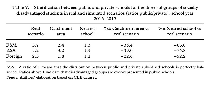
We compared these simulated scenarios with the current situation regarding school segregation and social stratification between public and private subsidised schools of Free School Meals (FSM) beneficiaries, Recipients of Social Allowances (RSA) and foreign students. (3/6)
Regarding school segregation, the results show that school segregation decreases significantly in both simulated scenarios: (4/6)
Social stratification between public and private subsidised schools also decreases dramatically, particularly in the nearest school scenario: (5/6)
Although the analysis has some limitations, it shows that school choice reforms fostering proximity schooling could contribute to tackling school segregation and the social stratification between private subsidised and public schools. (6/6)

 Read on Twitter


