#HeritageOnOurDoorstep makes us think of what’s local. Everywhere is connected to somewhere, and maps of places invite us to take journeys in space as well as time. For a small town, Carrickfergus on Belfast Lough is particularly rich in its historic maps, dating back 500 years.
The @IHTA_RIA Historic Towns Atlas of Carrickfergus gathers together examples of the town’s rich cartographic heritage https://www.ria.ie/sites/default/files/rtm_early_modern_plantation_towns_1.pdf https://www.ria.ie/irish-historic-towns-atlas-online-carrickfergus
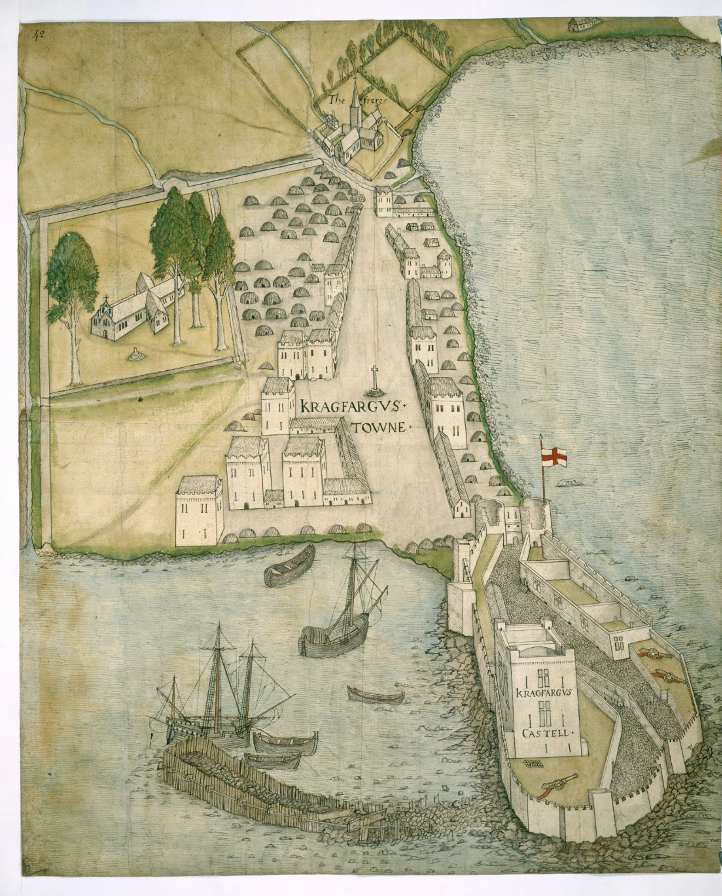
On an anonymous map, really a ‘bird’s eye’ perspective, of the castle and town of c.1560, the castle and harbour loom large, drawing attention perhaps to the need for funds to restore them. Intricate in its details, showing stone buildings, town defences and beehive huts...
...the trees around St Nicholas’ Church (on the left-hand side) are particularly distinctive on the map, almost exotic in appearance… https://www.bl.uk/collection-items/carrickfergus
Sometimes described as creaghts, the little beehive huts have caused much speculation. Considered traditionally Irish in their vernacular construction, they have been ascribed as anything from mobile army ‘tents’ to a form of transhumance booley huts, like a modern caravan...
Perhaps they were simply the most suitable housing type for withstanding inclement Irish weather? They are recognized on many Plantation settlement maps of this period. Interestingly they do not appear on any map of Carrickfergus post-1600?? Thoughts on a postcard??
At the end of the 16th century, Carrickfergus was well-connected to the wider, burgeoning Atlantic commercial world. Archaeological evidence from excavations in the town points to imports from the Continent - Iberia, France, the Netherlands, even China.
The town and castle on the c.1560 map might look small and its streets empty of people, but its large market place, marked by a cross, would have seen bustling trading of objects from overseas, especially the new North American colonies.
The analysis of the material evidence of Carrickfergus is largely complemented by the documentary evidence of trade, import/export taxation, and ships’ inventories.
Evidently, the residents of Carrickfergus capitalized on their maritime location, firmly inserting themselves into the European exchange market.
The expressions of sophisticated and varied consumer goods and luxury products, reflected in both the material culture and port accounts demonstrate the active engagement and participation in European commercial and consumer culture.
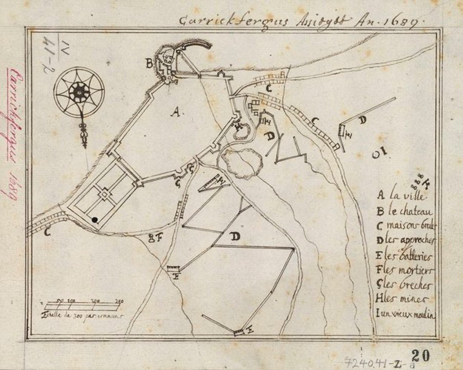
Maps tell stories of places and piecing together maps of Carrickfergus we can see how the town and castle changed over time. Outside influences on our localities are nothing new. Today—August 20th—in 1689, the siege of Carrickfergus began as part of the Nine Years War (1688-97)
This map shows trenches dug outside the walls of the town, as the Williamite army surrounded it. While the trenches have since disappeared, the legacies of the siege live on today… https://militarymaps.rct.uk/other-17th-century-conflicts/carrickfergus-1689-carrickfergus-assiegee-an-1689
Maps of places offer insights on local heritage, but they also point to wider worlds beyond our horizons, and how these outside cultural influences have shaped the places we know and value today. #Sharedheritage #carrickfergus #carrickfergusmuseum @mea_bc

 Read on Twitter


