The current fires in the #SantaCruzMountains (the CZU August Lightning Complex; https://rb.gy/owbdvk ) are devastating, but may help people unfamiliar with wildfire detection and monitoring better interpret active fire maps.
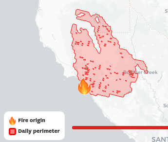
Fires are detected and reported in several ways: from on-the-ground reports to autonomous web cams to satellite observations. These data are often recorded as points across the landscape that represent where a fire started (the fire icon via @sfchronicle)
Active fire perimeters (the red outline above) are often derived on a daily basis by local fire teams, including all of the above tools as well as airborne overflights. This is a labor-intensive process—so perimeters are usually officially updated once per day.
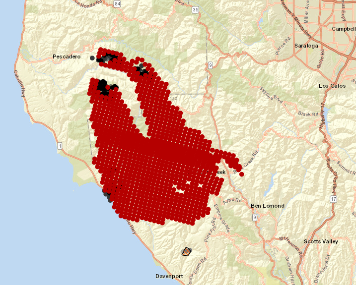
Satellite detection can be quicker—VIIRS detects fires twice daily (~1:30 am, pm). And they can identify remarkably small wildfires: despite imaging at ~140,000 square meters per pixel, VIIRS can detect bonfires-scale fires (ref: page 10 of https://rb.gy/t7f6fu )
(shout out to the @sfchronicle team for downloading and processing the satellite data to provide perimeters—it's not simple!)
But the reported fires can be noisy—we're measuring the earth's temperature from space, which is very cold and very far-away. And a small fire in a large pixel is reported for the whole area, so satellite detections often look blocky (per @WIFIREProject https://firemap.sdsc.edu/ )
The @WIFIREProject's Firemap is a great tool to explore these different datasets. They have current weather maps, fire weather forecasts, and they've aggregated both detection and perimeter data.
But you'll notice something strange when you look at the #SantaCruzMountains fire. It's spreading from south to north: the opposite direction that the winds are blowing. Huh?
Fast winds carry most of the fires that escape suppression—like the #LightningComplex that's rapidly and tragically moving through Vacaville—which are common in hot and dry inland landscapes dominated by grasses and shrubs.
But the Santa Cruz Mountains are different. They're coastal forests that experience cool, foggy conditions through most of the year. They don't experience the same hot and dry conditions as often as inland ecosystems.
And the fire only started last night—why is it moving so quickly? Against the winds, at that? In short: I don't factually know. But I suspect it has a lot to do with the volume of vegetation fuels that have accumulated for years across the landscape.
Here's a map of tree height across the region via the @forestobs, a new forest monitoring system we're building and planning to launch next month (check it out here https://tinyurl.com/yyczlvo5 ). It's got tons of huge trees—you can see the dense patches of redwoods in #BigBasin.
As a student at @ucsc I came to love exploring those dense, mountainous forests, especially the Redwoods. But dense forests accumulate leaf litter—it's part of why there are so many slugs there—which would normally propagate fires rapidly.
However, northern coastal forest don't burn often because the fog keeps the forest so damp (again, slugs). But under current #drought conditions, driven by #ClimateChange, coastal forests are much more susceptible to fire.
The dramatic #Lightning storm was likely enough to ignite a few large fires that were able to dry out the dense nearby vegetation along the fire front, and the fire would then be propagated by forest fuels alone.
Critically, the fire seemed to move with topography—starting from the coast and moving up the mountains with an assist from the rising heat along the flaming front. It's not clear yet where this fire will stop. And that uncertainty is horrific.
The current #CaliforniaFires are tragic, dramatic & complex. So many different dynamics are in play. I have the utmost respect for the #firefighters working to keep us safe. My heart goes out to all the communities being evacuated, and to everyone on the edge of their seat.
We're working now @SaloSciences to get the @forestobs built as fast as possible to ensure the best data on forest structure, weather & topography are available for free to researchers and emergency services teams to better prepare and respond to wildfire here in #California.
Stay safe everyone 


 Read on Twitter


