Why are we expecting such a big hurricane year?
Let's do what we do best: Look at the science for answers.
THREAD. 1/ https://twitter.com/NOAASatellitePA/status/1291400370703544321?s=20
Let's do what we do best: Look at the science for answers.
THREAD. 1/ https://twitter.com/NOAASatellitePA/status/1291400370703544321?s=20
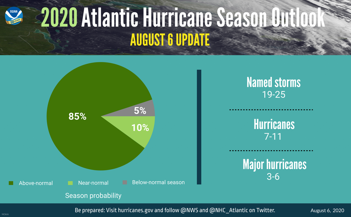
This year, NOAA is predicting 19-25 named storms. An average year has about 12.
"We've never forecasted up to 25 named storms. This is the first time," said Gerry Bell, the lead seasonal hurricane forecaster at NOAA. 2/
"We've never forecasted up to 25 named storms. This is the first time," said Gerry Bell, the lead seasonal hurricane forecaster at NOAA. 2/
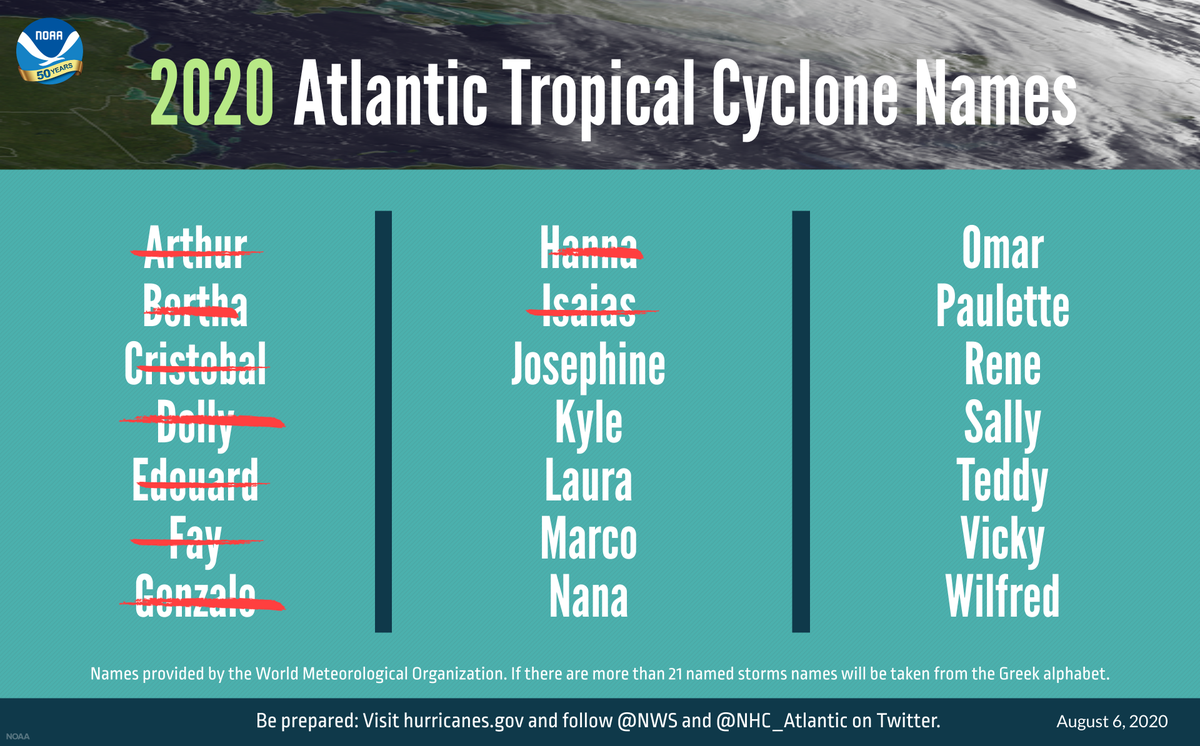
Already, we've had 9 named storms... if we run out of names (21), we'll have to switch to Greek letters. 3/
What's the science behind such an active season?
1. Warm ocean temperatures
2. Reduced vertical wind shear
3. Weaker trade winds
4. A strong West African Monsoon
Let's look at each of these and the drivers behind them. 4/
1. Warm ocean temperatures
2. Reduced vertical wind shear
3. Weaker trade winds
4. A strong West African Monsoon
Let's look at each of these and the drivers behind them. 4/
1. This year, Atlantic surface waters are the fourth warmest they’ve been since NOAA began keeping records in 1982.
Warmer than average ocean temperatures in the tropical Atlantic Ocean and the Caribbean Sea give storms the fuel they need to grow. 5/ https://www.nationalgeographic.com/science/2020/07/conditions-ripe-for-major-atlantic-hurricane-season/
Warmer than average ocean temperatures in the tropical Atlantic Ocean and the Caribbean Sea give storms the fuel they need to grow. 5/ https://www.nationalgeographic.com/science/2020/07/conditions-ripe-for-major-atlantic-hurricane-season/
2. In addition to warm waters, this year we don't have strong vertical wind shear to help disrupt storms.
Vertical wind shear is the change in wind speed and direction with height. Scientists track this to determine how favorable the atmosphere is for storms. 6/
Vertical wind shear is the change in wind speed and direction with height. Scientists track this to determine how favorable the atmosphere is for storms. 6/
2. (cont.) This year, we have reduced vertical wind shear... And that's unfortunate, because strong vertical wind shear can force storms to become "very lopsided or tilted in the vertical" thereby undermining them. 7/
https://www.accuweather.com/en/weather-news/what-is-wind-shear-and-how-does-it-impact-hurricanes-other-tropical-cyclones/330987#:~:text=Vertical%20wind%20shear%20is%20the%20change%20in%20direction%20and%20speed,increasing%20heights%20in%20the%20atmosphere.&text=When%20strong%20vertical%20wind%20shear,blown%20hundreds%20of%20miles%20downstream.
https://www.accuweather.com/en/weather-news/what-is-wind-shear-and-how-does-it-impact-hurricanes-other-tropical-cyclones/330987#:~:text=Vertical%20wind%20shear%20is%20the%20change%20in%20direction%20and%20speed,increasing%20heights%20in%20the%20atmosphere.&text=When%20strong%20vertical%20wind%20shear,blown%20hundreds%20of%20miles%20downstream.
3. Similarly, weaker tropical Atlantic trade winds this year creates a "more conducive structure" of the African Easterly Jet, encouraging hurricane development coming from Africa.
This factor gets a bit in the weeds, but you can read more about it: https://www.climate.gov/news-features/blogs/enso/impacts-el-ni%C3%B1o-and-la-ni%C3%B1a-hurricane-season 8/
This factor gets a bit in the weeds, but you can read more about it: https://www.climate.gov/news-features/blogs/enso/impacts-el-ni%C3%B1o-and-la-ni%C3%B1a-hurricane-season 8/
4. Lastly, a strong West African monsoon allows winds to "more easily spin up storms."
In summary, with conditions 1-4 this year, it sounds like we're in for a ride. 9/
https://www.noaa.gov/stories/whirlwind-of-atlantic-hurricane-season-what-gives
In summary, with conditions 1-4 this year, it sounds like we're in for a ride. 9/
https://www.noaa.gov/stories/whirlwind-of-atlantic-hurricane-season-what-gives
Now, what's driving these conditions?
Two things and a caveat...
1. La Nina a-brewing
2. A long-term climate signal called the Atlantic Multi-
Decadal Oscillation
10/
Two things and a caveat...
1. La Nina a-brewing
2. A long-term climate signal called the Atlantic Multi-
Decadal Oscillation
10/
1. We're currently on a "La Nina Watch." Conditions are favorable for La Nina to make its appearance in the next six months. So, keep an eye out.
La Nina further weakens wind shear. As we've covered, that lets storm develop unencumbered and leads to a bigger storm season. 11/
La Nina further weakens wind shear. As we've covered, that lets storm develop unencumbered and leads to a bigger storm season. 11/
2. We're also in the middle of a big climate signal that extends across the North Atlantic.
The Atlantic Multidecadal Oscillation is a naturally occurring change in sea surface temperature that lasts 20–40 yrs & stretches from the equator to Greeland.
https://www.aoml.noaa.gov/phod/amo_faq.php 12/
The Atlantic Multidecadal Oscillation is a naturally occurring change in sea surface temperature that lasts 20–40 yrs & stretches from the equator to Greeland.
https://www.aoml.noaa.gov/phod/amo_faq.php 12/
2. (cont.) Since 1995, we've been in the "warm" phase, which boosts sea surface temperatures, decreases the vertical wind shear, and enhances the African monsoon... which as we know, all favors a more extreme hurricane season. 13/
So again, in summary, La Nina and this natural climate signal called the Atlantic Multidecadal Oscillation are creating the atmospheric and oceanic conditions ripe for storms. 14/
Three to six storms this year could be major hurricanes of Category 3, 4, or 5. We won't know until a storm develops whether it'll make landfall and put people in harm's way.
Hurricane preparation may more difficult this year, given soaring coronavirus cases sweeping the US. 15/
Hurricane preparation may more difficult this year, given soaring coronavirus cases sweeping the US. 15/
If you live in a coastal or inland state affected by hurricanes, NOAA urges you to prepare now. August through October could be a very busy hurricane season. 16/
Lastly, a caveat.
While NOAA didn't attributing the big year to climate change in their forecast update today, and they will need to assess the season afterward to attribute any impacts to climate change... 17/
While NOAA didn't attributing the big year to climate change in their forecast update today, and they will need to assess the season afterward to attribute any impacts to climate change... 17/
... we do know that higher sea levels from climate change boosts storm surges.
This can be dangerous, and is one example of how rising seas from our Earth's melting ice sheets can affect someone's safety in their neighborhood and community thousands of miles away. 18/18
This can be dangerous, and is one example of how rising seas from our Earth's melting ice sheets can affect someone's safety in their neighborhood and community thousands of miles away. 18/18

 Read on Twitter


