1. This History Thread is about Burma (Myanmar) and natural disasters. Geography: Bay of Bengal & Sagaing Fault create conditions but disaster effects worsened by Climate Crisis, deforestation, economic/regional/ethnic inequality, info/funding/planning/academic gaps & corruption.
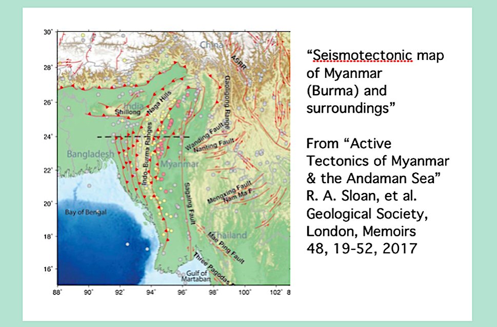
2. On edge of Indian Plate collision with Asia, Burma (Myanmar) has major north/south fault line (Sagaing Fault) & Burma Seismic Zone subduction & coastal subduction zone. Volcanoes are dormant but seismic activity in the form of earthquakes of various severity occurs frequently.
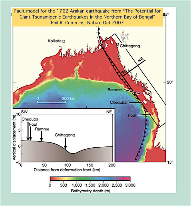
3. Ancient earthquakes formed & changed land that wd be known as Burma. 1762 Chittagong/Arakan earthquake (est 8.8) killed 200+ & elevated Arakan coastline. 1839 Mingun earthquake destruction Prome, Bhamo, Ava. Rang temple bells in Rangoon, felt in Moulmein. Years of aftershocks.
4. “Great Pegu Earthquake” 7.2 struck in 1930 central Burma, bent railway tracks, caused fire in Pegu, damage/deaths Rangoon, major aftershocks. Also 1931 major Myitkyina (Kachinland) earthquake. https://www.irrawaddy.com/specials/on-this-day/1930-earthquake-flattened-bago.html
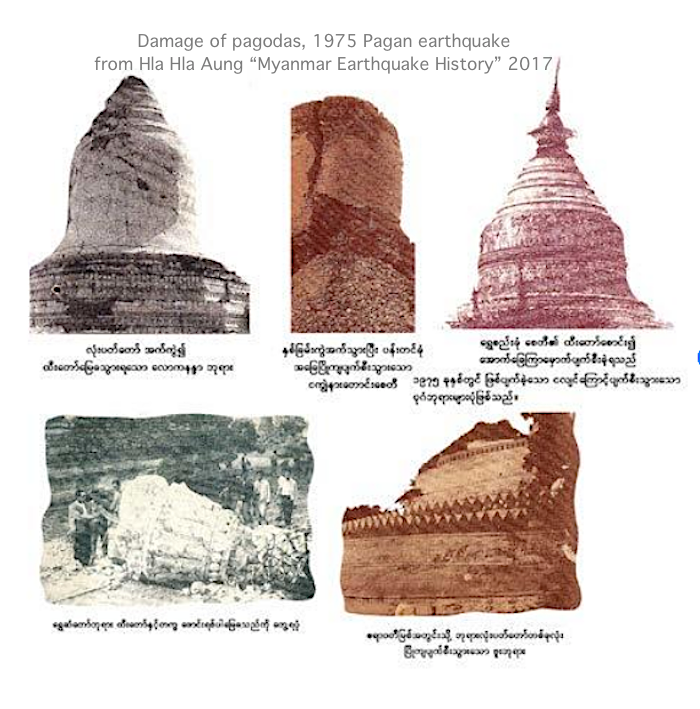
5. 1956: Sagaing earthquake 7.1 killed 38. 1975: Pagan 6.8 Pagan severely damaged archeological site. 2011: Shan Plateau 6.9 killed 74. 2012: Shwebo 6.8 killed gold miners, wrecked Irrawaddy River bridge. 2016: April 6.9 (India border) & August 6.8 (damaged Pagan/Bagan temples.)
6. Colonial through dictatorship Burma/Myanmar had few earthquake risk reduction efforts. Recent years w. INGOs developing risk assessment, city building codes, public awareness. Dams like China’s attempted Myitsone (Kachinland) are earthquake breach risk. http://www.voanews.com/east-asia-pacific/myanmar-wakes-grave-earthquake-threat
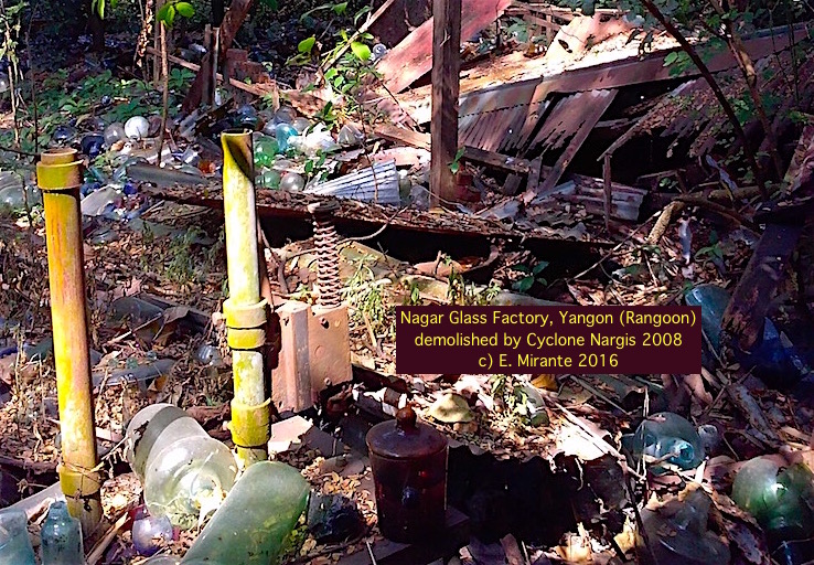
7. Myanmar coast Bay of Bengal, Andaman Sea vulnerable to severe seasonal cyclonic storms. Mangrove deforestation, warning failures worsen effects. Cataclysmic cat. 4 Cyclone Nargis May 2008, Irrawaddy Delta tidal surge, 200+ km/hr winds, killed 138,000+.
8. My 2 part 2008 @GuernicaMag essay on the SPDC political/economic context (including aid obstruction) of Cyclone Nargis, “The Ruby Ape: A Deadly Storm and a Lethal Regime”: http://www.guernicamag.com/edith_mirante_the_ruby_ape_a_d/
9. Climate Crisis: severe Myanmar storms incl. 2010 Cyclone Giri cat. 4 Rakhine St. killed 150+. 2015 Cyclonic storm Komen heavy rains + extreme flooding in Rakhine, Sagaing, Magway & massive landslides in Chin St. 2017 Cyclone Mora cat. 1 caused flooding & tornado in Rakhine St.
10. Landslides cause multiple fatalities in Myanmar every year. Deforested mountains are unstable. Mining especially jade region Hpakant (Kachinland) causes lethal industrial erosion. Dave Petley est. nearly 1,000 killed in Hpakant landslides 1/15-5/19. https://frontiermyanmar.net/en/the-jade-mining-crisis
11. During British colonial occupation Burma weather described as “predictable” - rain patterns benefiting rice agriculture & river water for irrigation. Under post-Independence military dictatorship watersheds largely intact until SLORC/SPDC timber concessions decimated forests.
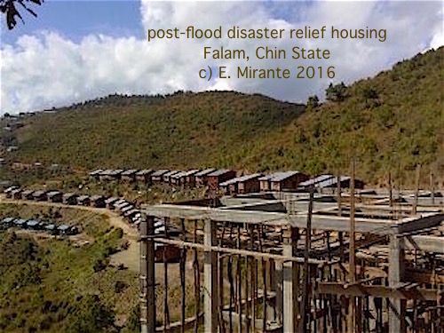
12. Myanmar monsoon floods new normal (deforestation, dam breaches, mining, Climate Crisis.) July-Aug. 2019 rivers flooded s. & cen. Myanmar. July '18 120,000 displaced by floods, landslides. ’16 floods: almost half million affected. ’15: million affected. http://www.theguardian.com/world/2019/aug/12/myanmar-scrambles-to-rescue-flood-victims-as-landslide-kills-dozens
13. Flood mitigation programs for rural and urban Myanmar, with local & international expertise, should include river bank erosion control/repair, watershed & delta replanting, flood prediction sensing & evacuation communication measures. https://www.mmtimes.com/business/16209-never-again-flood-proofing-myanmar.html
14. Central Burma/Myanmar Dry Zone drought years incl. 1811-12, 1980-83, 2010. Drought from insufficient monsoon rain. Deforestation, Climate Crisis intensify drought. Soil depletion, crop failure. Ground cover planting, drought resistant crops needed.
15. FAO 2019 “Myanmar has highest burn rate in Southeast Asia & ranks 11th globally in terms of forest fires. Between 2003 & 2012 more than 17.732 million hectares burned in Myanmar.” Accidental or uncontrolled forest/plantation/farming wildfires. https://earthobservatory.nasa.gov/images/18070/fires-in-myanmar
16. Lightning strikes are a major hazard in Myanmar, killing 133 people in 2019. Most casualties are outdoors but indoor electricity adds to lightning danger. (note: mobile phones not a lightning hazard unless plugged in.) http://www.irrawaddy.com/news/burma/lightning-strikes-killed-62-myanmar-year.html
17. Intense hailstorms seem to be more common in Myanmar last few years. Climate Crisis may lessen frequency but increase size of hail, which can destroy crops, buildings, livestock (hailstorm killed 600 chickens in Sagaing 2017.)
Note: loud video. http://www.express.co.uk/news/weather/672928/Giant-hailstorms-Myanmar-deadly-storm-killing-damaging-buildings
Note: loud video. http://www.express.co.uk/news/weather/672928/Giant-hailstorms-Myanmar-deadly-storm-killing-damaging-buildings
18. Bamboo species flowers in 48 yr cycle NE India, Bangladesh Hills, NW/N Myanmar causing surge of rats which obliterate crops. 1958-59 regional Mautam famine resulted. Myanmar SPDC didnt prepare for 2006-08 Mautam food insecurity. My Project Maje report: http://www.projectmaje.org/mautam.htm
19. Myanmar one of highest Climate Crisis impact countries w. Cyclone Nargis damage & deaths, increase in cyclones. Monsoon rain irregularities (SW monsoon getting shorter) = food/water insecurity. High temps increasing w. heat related deaths (260 in 2010) https://theaseanpost.com/article/myanmar-risk-extreme-climate
20. Myanmar deforestation, agricultural burning, coal fired power plants contribute to Climate Crisis. Myanmar needs agriculture adaptation, mangrove restoration, forest protection, alternative energy (including solar, micro-hydro, Chin St. wind power.) http://www.mmtimes.com/news/preparing-next-disaster.html
21. Myanmar disaster response has long relied on volunteer relief efforts (notably after Cyclone Nargis.) Much more preparedness needed. Construction adaptation for earthquakes & floods, mitigating erosion & deforestation, risk education, warning systems. http://www.mmtimes.com/news/disasters-2019-highlight-need-comprehensive-mitigation-programme.html
22. Some sources. Earthquake: Chhibber 1933, MacRae et al. 2011, Sloan 2017, Hla Hla Aung 2017. Landslide: Petley blog 2018. Flood: Brakenridge et al. 2016. Drought: D'Arrigo et al. 2011, Tin Yi Myanmar DMH (2016?) My previous History Threads & reports at http://www.projectmaje.org

 Read on Twitter
