Several #Arctic locations recorded land surface temperatures hitting 45C on 19 June, according to initial data from the @esa satellite Sentinel-3.
Here is what you need to know... (THREAD 1/7) https://twitter.com/defis_eu/status/1275337831704035328
Here is what you need to know... (THREAD 1/7) https://twitter.com/defis_eu/status/1275337831704035328
Also widely reported is a potential new Arctic temperature record of 38C in Verkhoyansk – a town in #Siberia, Russia – on 20 June
See @CarbonBrief’s Daily Briefing: https://www.carbonbrief.org/daily-brief/uk-public-supports-green-recovery-from-coronavirus-crisis
So why is 38C potentially a new record, but not 45C?
2/7
See @CarbonBrief’s Daily Briefing: https://www.carbonbrief.org/daily-brief/uk-public-supports-green-recovery-from-coronavirus-crisis
So why is 38C potentially a new record, but not 45C?
2/7
The 45C reading is land surface temp – how hot the surface is to the touch – which is commonly measured by satellites.
The 38C reading is surface air temp – how warm the air is just above the ground. This is what is you usually see in weather forecasts and climate data.
3/7
The 38C reading is surface air temp – how warm the air is just above the ground. This is what is you usually see in weather forecasts and climate data.
3/7
Typically, on a sunny day, the land surface temperature will be warmer than the air above it (see this paper: https://journals.ametsoc.org/jamc/article/50/3/767/13630/Evaluation-of-the-Relationship-between-Air-and)
But there’s no fixed relationship between the two as this varies with weather conditions
4/7
But there’s no fixed relationship between the two as this varies with weather conditions
4/7
Siberia’s heatwave is primarily the result of a “blocking” weather pattern. This is when a weather system – usually a high-pressure one – gets stuck in one place for days or even weeks.
Read more in @CarbonBrief’s Q&A: https://www.carbonbrief.org/jet-stream-is-climate-change-causing-more-blocking-weather-events
5/7
Read more in @CarbonBrief’s Q&A: https://www.carbonbrief.org/jet-stream-is-climate-change-causing-more-blocking-weather-events
5/7
The block means any oncoming (cooler, wetter) weather is deflected away or also stays put.
Summer blocking events were the root cause of other major heatwaves, e.g. Europe in 2003 & Russia in 2010.
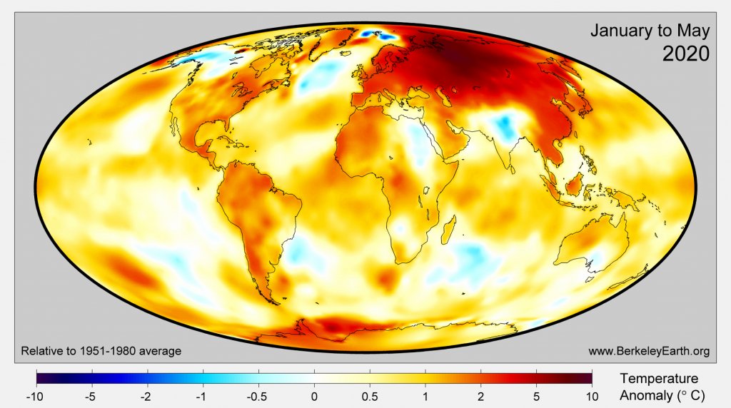
As this @BerkeleyEarth map shows, Siberia has seen a very warm 2020 so far
6/7
Summer blocking events were the root cause of other major heatwaves, e.g. Europe in 2003 & Russia in 2010.
As this @BerkeleyEarth map shows, Siberia has seen a very warm 2020 so far
6/7
Siberia is covered by vast stretches of #permafrost – frozen ground storing billions of tonnes of carbon.
High temperatures cause permafrost to thaw and potentially emit its long-held carbon. For more, see this @CarbonBrief guest post by @schaedelc
https://www.carbonbrief.org/guest-post-the-irreversible-emissions-of-a-permafrost-tipping-point
7/7
High temperatures cause permafrost to thaw and potentially emit its long-held carbon. For more, see this @CarbonBrief guest post by @schaedelc
https://www.carbonbrief.org/guest-post-the-irreversible-emissions-of-a-permafrost-tipping-point
7/7

 Read on Twitter


