Right then, a short thread.
Today the #GeospatialCommission launched the UK's #Geospatial Strategy, 2020 to 2025 https://www.gov.uk/government/publications/unlocking-the-power-of-locationthe-uks-geospatial-strategy + press release https://www.gov.uk/government/news/unlocking-the-power-of-location-the-uks-geospatial-strategy #UKGeospatialStrategy #UnlockingLocation
1/n
I refer you to @GeospatialC for the official tweets.
The launch event was recorded, so I expect a video will appear in due course. https://virtual.digileaders.com/talks/unlocking-the-power-of-location-the-uks-geospatial-strategy/
2/n. https://twitter.com/GeospatialC/status/1272858032997904384
The launch event was recorded, so I expect a video will appear in due course. https://virtual.digileaders.com/talks/unlocking-the-power-of-location-the-uks-geospatial-strategy/
2/n. https://twitter.com/GeospatialC/status/1272858032997904384
Conventionally, a strategy has a set of aims and an action plan. It is difficult to find either in today's paper. Mainly it combines an update on GC activities with some generic horizon scanning. There is no real sense of ambition or potential for impact on public policy.
3/n
3/n
Evident throughout is the lack of political appetite for unlocking value from public geospatial data.
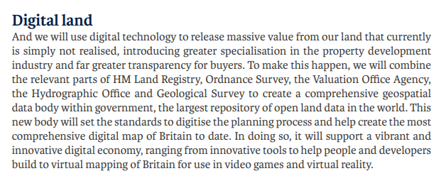
It's worth looking back to the GC's origins in the 2017 Conservative Party manifesto: https://www.owenboswarva.com/opendata/Manifesto2017.pdf#page=84
Three years later, that bold vision has vanished entirely.
4/n
It's worth looking back to the GC's origins in the 2017 Conservative Party manifesto: https://www.owenboswarva.com/opendata/Manifesto2017.pdf#page=84
Three years later, that bold vision has vanished entirely.
4/n
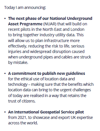
Today's #UKGeospatialStrategy launch included three new announcements, none of them significant enough to require any mention of funding.
(The NUAR is a worthwhile initiative but I doubt the business case relied on sponsorship from a Cabinet Office commission.)
5/n
(The NUAR is a worthwhile initiative but I doubt the business case relied on sponsorship from a Cabinet Office commission.)
5/n
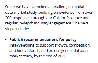
Perhaps the most telling section of the paper: recommendations for policy interventions "by the end of 2020".
Was it unreasonable to expect policy recommendations in today's five-year strategy?
Two years after it was set up, the GC is still kicking the can down the road.
6/n
Was it unreasonable to expect policy recommendations in today's five-year strategy?
Two years after it was set up, the GC is still kicking the can down the road.
6/n
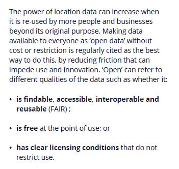
Nothing new on #opendata in the #UKGeospatialStrategy.
There's a section on improving access to public sector data in which the GC tortures the definition of 'open' so as to give the impression that FAIR data and free data are equivalent concepts. https://gov.uk/government/publications/unlocking-the-power-of-locationthe-uks-geospatial-strategy/unlocking-the-power-of-location-the-uks-geospatial-strategy-2020-to-2025#improving-access-to-public-sector-data
7/n
Much of this section is taken up by a defensive, Treasury-inflected argument about the options for funding public sector data. This argument fails to distinguish between use and re-use of public data and affects (I assume) an ignorance of the economics of digital goods.
8/n
8/n
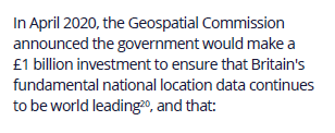
Some interactions between the #UKGeospatialStrategy and the OS data reforms announced in April:
Actually I think this is the first time Government has mentioned the £1 billion cost of PSGA. It was in the contract notice but not announced in April. https://www.gov.uk/government/news/government-announces-new-10-year-public-sector-geospatial-agreement-with-ordnance-survey
9/n
Actually I think this is the first time Government has mentioned the £1 billion cost of PSGA. It was in the contract notice but not announced in April. https://www.gov.uk/government/news/government-announces-new-10-year-public-sector-geospatial-agreement-with-ordnance-survey
9/n
I think this is also the first explicit confirmation that delivery of existing OS #OpenData products (previously funded under a separate contract) has been rolled into PSGA. This wasn't provided for in the contract notice. https://ted.europa.eu/udl?uri=TED:NOTICE:215866-2020:TEXT:EN:HTML
That's good news I guess.
10/n
That's good news I guess.
10/n
Hmm.
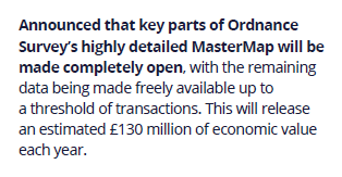
OS measures outlined in 2018 were expected to deliver value of £130 million each year. https://www.gov.uk/government/news/unlocking-of-governments-mapping-and-location-data-to-boost-economy-by-130m-a-year
OS has since cancelled the topline measure: #opendata release of property extents.
Yet the remaining measures will still deliver value of £130 million?
11/n
OS measures outlined in 2018 were expected to deliver value of £130 million each year. https://www.gov.uk/government/news/unlocking-of-governments-mapping-and-location-data-to-boost-economy-by-130m-a-year
OS has since cancelled the topline measure: #opendata release of property extents.
Yet the remaining measures will still deliver value of £130 million?

11/n
I am actually slightly surprised today's #UKGeospatialStrategy launch didn't include an announcement on #opendata release of @HMLandRegistry's INSPIRE polygons. It would've been good will for the GC and cost them nothing. https://www.owenboswarva.com/blog/post-gc4.htm
12/n
12/n
Anyway, that's enough for now.
Wake me when the National Data Strategy gets here.
13/13
Wake me when the National Data Strategy gets here.
13/13

 Read on Twitter